At a glance
What you’re signing up for
Map
Find it on the map
Honest gut-check
Is Camp Muir the right hike for you?
Camp Muir is a serious above-treeline route on permanent snow. It rewards strong, prepared hikers — and it has specific requirements that aren't negotiable at 10,000 feet.
Go for it if…
You want the highest point on Rainier that doesn't require a climbing permit
Camp Muir at 10,188 ft is the top of the non-technical route. Above it, the standard summit route requires roped glacier travel and a climbing registration.
You're a strong hiker comfortable on steep snowfields
The Muir Snowfield covers the upper half of the route year-round. You'll be walking on snow even in August. The snowfield has no crevasses on the route but is steep and icy early in the day.
You have 7–8 hours and want a full alpine day
This is not a casual hike. Expect 4–5 hours up, 2.5–3 hours down, plus time at the hut. Start before 7 AM to reach Muir in reasonable conditions.
You're considering the technical summit but want to preview the terrain
Many guided summit climbers do Camp Muir as a conditioning hike in the weeks before their scheduled climb.
Maybe skip it if…
You don't have mountaineering basics
The Muir Snowfield is snow, not a trail. Navigation requires being able to hold a bearing in whiteout conditions — afternoon fog rolls in fast and the snowfield has claimed lives when hikers descend off-route.
You're arriving without microspikes and an ice axe in early season
Before mid-August the snowfield can be hard ice in the morning. Microspikes are the minimum; an ice axe adds a meaningful safety margin if you've practiced self-arrest.
The afternoon weather looks uncertain
Turn around by 1–2 PM regardless of how good you feel. Afternoon thunderstorms build fast above the snowfield and you want to be below treeline before they arrive.
You're looking for wildflowers or meadow scenery
The Muir Snowfield is a permanent snowfield. There are no wildflowers above the Paradise meadows — only snow, rock, and a vertical mile of climbing. The Skyline Loop delivers the wildflower experience from the same trailhead.
The experience
What it actually feels like
The route from Paradise to Camp Muir — what changes at each elevation band, what the snowfield actually requires, and what you find at the top.
What Camp Muir is — and where the technical climb begins
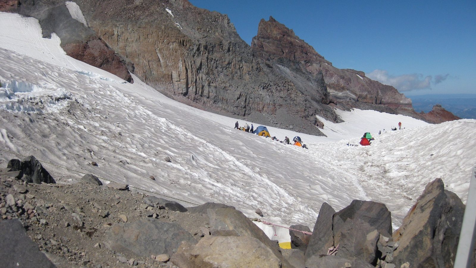
Camp Muir at 10,188 feet is a cluster of stone huts on a rocky promontory above the Muir Snowfield. It's the staging point for technical summit climbs above — where roped teams gear up, where guided-climb clients sleep the night before their summit push, and where the standard non-technical day hike ends.
From the Paradise visitor center at 5,400 ft, the route climbs through the wildflower meadows (snow-free in summer), transitions to the rocky Skyline Trail, and then steps onto the Muir Snowfield at roughly 7,000 ft. From there it is 3+ miles of open snowfield to the hut, with the mountain's south face growing in front of you the entire way.
The Muir Snowfield — the heart of the route
The Muir Snowfield is a permanent glacier-fed snowfield, not a seasonal snowpack. It runs from roughly 7,000 ft to Muir at 10,188 ft and covers the upper half of the route year-round. In June and early July the surface is hard-packed ice in the morning hours; by August the snow softens to consolidated firn that gives better traction.
Navigation is the primary hazard. The snowfield is featureless — no trail, no markers visible in poor visibility — and it sits above a slope that falls away to the Nisqually Glacier below. In afternoon cloud or fog, the route down is not obvious. Carry a compass bearing and know how to use it: the safe descent line from Camp Muir runs roughly due south to the Paradise valley.
The Muir Snowfield has no crevasses on the hiking route. What it has is slope, featureless visibility when clouds come in, and a consequence for wandering off-line. Navigation is the actual skill this hike requires.
At Camp Muir
The hut complex includes a public shelter (no overnight stays without backcountry permit), ranger station (staffed in summer), and outhouses. Most day hikers spend 20–30 minutes at the top, eat something warm, and start down.
The descent on the snowfield is faster but requires attention. The tendency is to drift left (north) on the descent — which leads off the safe line toward the Cowlitz Glacier. Navigate by compass bearing or stay oriented to the Paradise parking lot below you. Down-climbing the snowfield on microspikes is faster and more secure than trying to glissade on icy surfaces.
Timing
When to go
Peak season (August) gives the best snowfield conditions. Early summer is icy and serious; late fall can bring new snow. Pick your window carefully.
- Temps
- 25–55°F on snowfield
- Crowds
- Moderate
- Shuttle
- Check NPS.gov
- Permit lottery
- No permit for day hike to Muir; no Paradise timed entry for 2026 — confirm NPS status
Snowfield is hard ice in the morning. Microspikes mandatory; ice axe recommended. Route can be corniced at Muir rim. Start very early to avoid afternoon softening and cloud build-up.
- Temps
- 30–60°F on snowfield
- Crowds
- Busiest
- Shuttle
- Check NPS.gov
- Permit lottery
- No permit for day hike; timed entry for Paradise
Snow consolidated and walkable from early morning. Ranger station usually staffed. Best weather and visibility. Still turn around by 1 PM — afternoon clouds build above the snowfield.
- Temps
- 20–50°F on snowfield
- Crowds
- Light
- Shuttle
- Limited or not operating
- Permit lottery
- No permit for day hike
New snowfall can arrive on the upper snowfield in September. The consolidated August surface may be replaced with fresh, unconsolidated snow that's harder to navigate. Excellent visibility on clear days; Paradise road may close without notice after major snowfall.
Snowfield and trail conditions at Camp Muir change week to week. Check current NPS conditions before your trip: NPS Mount Rainier climbing conditions
Gear
What to bring
The gear list for Camp Muir is different from a trail hike. Microspikes, compass, and water are the three items that determine whether this goes well or badly.
Non-negotiable
Microspikes
Required for the Muir Snowfield in all conditions except late August consolidated corn. Without traction, descent on hard morning ice is extremely dangerous.
Compass (not just a phone GPS)
The snowfield is featureless in cloud. GPS helps but a bearing compass doesn't fail when your phone battery dies at altitude. Know your descent bearing from Muir before you go up.
3+ liters of water
No water above the Paradise visitor center. The climb to 10,188 ft takes 4–5 hours at elevation; dehydration compounds altitude effects significantly.
Current entry status (check before you go)
No timed-entry reservation is required for Paradise in 2026 (the 2024–2025 pilot was discontinued; parking management replaces it). It has been required in past summers and may return — confirm the current status on the NPS Mount Rainier page, and arrive early either way (the lot fills by mid-morning).
Check current status on NPS.gov →Strongly recommended
Ice axe (early season)
Before mid-August: a meaningful safety margin on the steeper snowfield sections. Know how to self-arrest before bringing one — a self-arrest attempt without training is not reliable.
Sunglasses with UV400 rating
Sun reflected off snow at 7,000–10,000 ft causes snow blindness in 2–3 hours without protection. Polarized glacier glasses are better than standard sport sunglasses.
High-calorie food
The climb burns 800–1,200 calories. Your body works harder at altitude and the cold suppresses the hunger signal — eat on a schedule, not when you feel hungry.
Wind shell and insulating layer
The snowfield is exposed. Wind at 9,000–10,000 ft with a 25-knot west wind makes a 45°F day feel like 25°F. Pack layers you can add at the top while you stop moving.
Leave it behind
Dogs
Not allowed on Paradise trails or on the Muir Snowfield.
Ski poles (in crampons / microspikes)
On icy snowfield sections where you need an ice axe for self-arrest, poles are a false substitute. They're useful on soft snow in August but don't replace proper safety equipment in harder conditions.
Backup plans
Always have a Plan B
Not ready for the snowfield? Want to go higher than Muir? Here are the two main alternatives.
Save on Entry
One pass covers Mount Rainier — and every other US national park.
The America the Beautiful annual pass pays for itself in two or three park visits. Free entry, free passenger fees, and no more fumbling for a credit card at the kiosk.
 Buy your pass →
Learn more about the pass
Buy your pass →
Learn more about the pass
Ships from US Park Pass. Free shipping in the continental US.