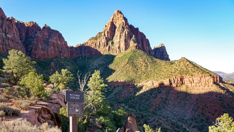
PARKS Atlas
Two hikers in matching blue jackets walk along a rustic dirt trail flanked by a wooden fence and vibrant autumn foliage in shades of yellow, orange, and red,…

Utah · National Park · Trails

Hiking in Zion

From chain-clutch ridgelines to waist-deep river canyons — every trail puts the wall right above your head.

Map

Explore Zion

Explore more

Trails

Ten trails worth your time in Zion

Zion is a hiker's park. Most of the high points sit at the end of a trail — the shuttle drops you at the canyon floor and the routes climb from there. These ten trails cover the full spread: chain-clutch ridgelines, waist-deep river canyons, paved riverside walks, and the half-mile payoff hike east of the tunnel. Pick by time on foot, by who you're hiking with, and by whether you're holding a permit.

A hiker looking out over a sweeping Zion Canyon vista from a layered sandstone overlook

Scout Lookout via West Rim Trail

4.9 (20,010)

3.8 mi 1,141 ft gain 2.5–3 hr

Hard Out & back

Same trailhead and switchbacks as Angels Landing but stops at Scout Lookout — no chains, no permit, and the same canyon overlook the chain section leads to. The smart play if the Angels Landing lottery didn't go your way.

A lone hiker wading the Virgin River between the towering sandstone walls of The Narrows in Zion

The Narrows (Bottom Up to Big Springs)

4.8 (6,209)

9.3 mi 872 ft gain 5–8 hr

Hard Out & back

Wade straight up the Virgin River where the canyon pinches to 20 feet wide. The bottom-up day hike from Temple of Sinawava needs no permit — turn around at Big Springs. Rent neoprene socks and a walking stick in Springdale.

The Virgin River flowing past smooth boulders deep within the red sandstone walls of The Narrows in Zion

The Narrows (Top Down)

4.8 (1,522)

16.8 mi 2,076 ft gain 8–10 hr

Strenuous Point to point Permit required

The full through-hike from Chamberlain's Ranch. Permit required — caps at 80 hikers per day. Arrange a shuttle from Springdale. Can be done as an overnight with reserved campsites. The deepest water and tallest walls are in the final 4.5 miles.

A paved riverside trail winding along the Zion Canyon floor beneath towering red sandstone cliffs

Floating Rock via Narrows Riverside Walk

4.9 (16,174)

6.4 mi 1,581 ft gain 3.5–4 hr

Moderate Out & back

A taste of the Narrows without the full commitment. Starts on the paved Riverside Walk, then continues into the river to Floating Rock. The water gets knee- to waist-deep — proper shoes are non-negotiable.

A sweeping aerial view of Zion Canyon with red sandstone cliffs flanking the Virgin River valley

Observation Point via East Mesa Trail

4.8 (9,665)

7.0 mi 705 ft gain 2.5–3 hr

Moderate Out & back

The big view down onto Angels Landing — taller, quieter, and now best approached from East Mesa Trailhead (4WD required) while the original Weeping Rock route remains closed. Sunrise is the move.

The view from Canyon Overlook across Zion Canyon, with red sandstone cliffs above a winding road

Canyon Overlook Trail

4.8 (15,954)

1.0 mi 216 ft gain 30 min

Moderate Out & back Kid friendly

The highest payoff-per-step trail in the park. Just east of the Mt. Carmel tunnel, 30 minutes to a railing perch over Pine Creek Canyon. No shuttle needed — drive to it. Sunrise and sunset are the moves.

A waterfall cascading down striated red sandstone canyon walls in Zion National Park

Emerald Pools Trail

4.6 (7,228)

3.0 mi 583 ft gain 1.5–2 hr

Moderate Loop Kid friendly

A tiered set of seep-fed pools and waterfalls below the Court of the Patriarchs. Lower pool is stroller-friendly on a paved path; upper pool is a steeper scramble but worth it after spring runoff. Watch your footing — more injuries here than any trail in the park.

The Virgin River winding through Zion Canyon below the Watchman peak under a blue sky

The Watchman Trail

4.7 (22,812)

3.3 mi 636 ft gain 1.5–2 hr

Moderate Out & back Kid friendly

Overlooked because it's right at the south entrance while everyone rushes to the shuttle. Steady switchbacks to a plateau overlooking Springdale, the Watchman tower, and Bridge Mountain. Best at sunset when the crowds have cleared.

Autumn cottonwood trees lining the Virgin River below the Watchman peak in Zion Canyon

Pa'rus Trail

4.5 (7,862)

3.3 mi 144 ft gain 1–1.5 hr

Easy Out & back Dog friendly Kid friendly

The only trail in Zion that allows dogs (leashed) and is fully paved, wheelchair-accessible, and stroller-friendly. A flat riverside walk with cottonwood shade and canyon vistas. The wind-down hike after a big day. Note: toxic algae in the river — keep dogs out of the water.

A narrow slot canyon with smooth, wave-like sandstone walls curved into a tunnel shape, with shallow water flowing along the canyon floor.

The Subway

8.1 mi 606 ft gain

Strenuous Point to point Permit required

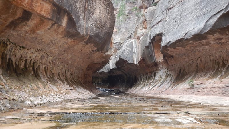
A technical canyoneering route (rated 3B III) down the Left Fork of North Creek, named for the tube-shaped slot at its heart. The top-down version from Wildcat Canyon to the Left Fork trailhead involves rappels, downclimbing, route-finding, and several cold swims, so it calls for canyoneering gear and experience. Every route through the Subway needs a Zion wilderness permit, issued by lottery on Recreation.gov. A non-technical bottom-up day hike reaches the formation from the Left Fork trailhead — still permitted, no rappels, but a long rock-hop with stream crossings.

A natural sandstone arch spans across layered red rock cliffs in bright midday sun, with lush green vegetation and dead snags in the canyon below.

Kolob Arch via La Verkin Creek Trail

14.2 mi 1,719 ft gain 6–6.5 hr

Hard Out & back

The signature hike of Zion's quieter Kolob Canyons district, starting from the Lee Pass trailhead off I-15 exit 40. The trail follows Timber Creek and then La Verkin Creek about 7 miles each way to Kolob Arch — among the largest free-standing arches in North America. The day round-trip needs no permit; overnight trips use the 13 designated backpacking sites, which require a Zion wilderness permit and reservation. Filter water from springs only — toxic cyanobacteria have been found in La Verkin Creek. Best spring through fall; snow can linger on the trail into early spring.

A hiker with an orange backpack and cap stands on layered red sandstone ledges gazing at the towering vermilion cliffs and mesas of Zion National Park, bathe…

West Rim Trail

14.9 mi 1,433 ft gain

Hard Point to point

Zion's high-country traverse, run top-down from Lava Point to The Grotto so the 14.9 miles descend more than they climb. The route crosses the Horse Pasture Plateau with long views toward Greatheart Mesa and the Right Fork before dropping through the White Cliffs into Zion Canyon, joining the Angels Landing route near Scout Lookout. Because it runs point-to-point, you need a shuttle or second car to reach Lava Point — there is no park transit to the trailhead, and the road closes with winter snow. Most hikers split it over two days at the permitted backcountry campsites; strong hikers do it in one long day. Overnight stays require a Zion wilderness permit and reservation.

Taylor Creek Trail

4.8 (5,996)

5.1 mi 633 ft gain 2–2.5 hr

Moderate Out & back

The marquee day-hike of the Kolob Canyons section, starting just off I-15 exit 40. The Middle Fork of Taylor Creek runs about 2.7 miles each way to the Double Arch alcove, crossing the creek more than a dozen times and passing two weathered homestead cabins along the way. It's a moderate, mostly shaded streambed grade with no big climbs — cool deep in the finger canyon even in summer. No permit or shuttle: the trailhead is two miles up the Kolob Canyons scenic drive. Spring runoff makes the crossings wet, and the group-size limit is 12.

Timber Creek Overlook Trail

4.7 (3,019)

1.2 mi 259 ft gain 0.5–1 hr

Moderate Out & back

The easy payoff at the end of the Kolob Canyons scenic drive — a nearly flat 1.2-mile walk along a ridge with head-on views of the finger canyons, the Kolob Terrace, and the Pine Valley Mountains. On a clear day you can pick out Mt. Trumbull on the Grand Canyon's north rim, 100 miles south. Spring and early summer bring desert wildflowers and the odd collared lizard. Parking, restrooms, and picnic tables at the trailhead make it the natural first or last stop in Kolob.

Trail data powered by AllTrails. Save offline maps, see live conditions, and download GPX tracks with AllTrails+.

Zion trail conditions alerts

One email when smoke, storm, or fire affects Zion trail access. Trail-specific — not the same as our lodging alerts.

Save on Entry

One pass covers Zion — and every other US national park.

The America the Beautiful annual pass pays for itself in two or three park visits. Free entry, free passenger fees, and no more fumbling for a credit card at the kiosk.

America the Beautiful National Park Pass — the 2026 annual pass card Buy your pass → Learn more about the pass

Ships from US Park Pass. Free shipping in the continental US.